Location: Ngonye Falls National Park
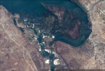
Photo: Annette Willemen
Ngonye Falls National Park, mainland and island
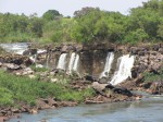
Photo: Annette Willemen
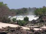
Photo: Annette Willemen
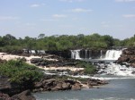
Photo: Annette Willemen
General Information
Quarter degree square: 1623D1 Country: Zambia Habitat: Altitude range: 1000 m Annual rainfall: 551-650 mm Location (short): It lies at southern end of the Barotseland floodplains Location (detailed): National Park No. 20, Senanga District |
Description
Basalt dykes crossing the path of the Zambezi R. at the southern end of the Barotseland floodplains produce rapids and low waterfalls. The largest being the Ngonye Falls (Sioma Falls) which are cresent-shaped and drop 23 m into a short gorge. There are 24 sets of rapids between Ngonye and Katima Mulilo.
Useful links
View a list of records for Ngonye Falls National Park
View a list of unique taxa (excluding cultivated plants) for Ngonye Falls National Park
View a list of unique taxa (all taxa whether cultivated or not) for Ngonye Falls National Park